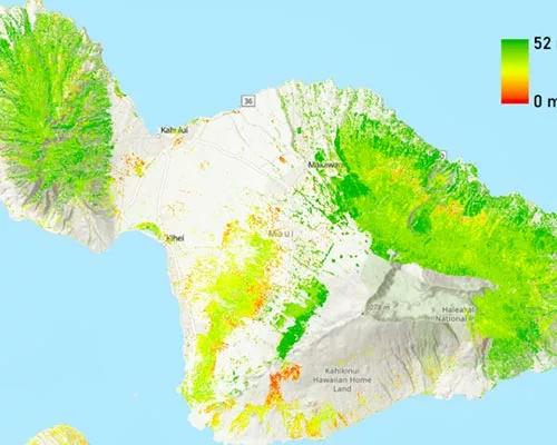
A groundbreaking new 30-meter Maui Forest Height Map reveals that trees on the Valley Isle are taller than previously thought, challenging past assumptions about the island’s forest elevation. The map, developed by a CSS geography professor, has implications that extend beyond cartography and that could impact future environmental resource management in all areas, including Lahaina.
Qi Chen, project lead, utilized remote sensing technology (airborne lidar) as reference data to train models based on satellite imagery, surpassing the accuracy of traditional mapping methods. Similar to how medical professionals use x-rays to assess the human body, researchers analyzed the colors and values of each pixel in satellite and lidar imagery to infer the height of trees at various locations.
“The revised height estimates for Maui’s forests have significant implications, influencing factors such as water yield, carbon sequestration and wildlife habitat suitability,” said Chen.
Justin Kellum, a graduate student in geography, played a crucial role in analyzing airborne lidar data for the project.
“It was a great experience to work directly with Dr. Chen in reviewing and editing airborne lidar data for this project, which resulted in such a significant effort,” said Kellum.
Identifying the horizontal spread of forests is relatively straightforward, but determining their vertical height has been a persistent challenge. Accurate information about forest height is crucial for various reasons.
Taller trees, for example, may increase the risk of specific types of fires, and forests with diverse heights tend to support more biodiversity. Moreover, understanding variations in tree height is essential for calculating carbon sequestration rates, playing a vital role in efforts to combat global warming and address climate change.
“The revised height estimates for Maui forests will help enhance the accuracy of calculations for factors like evapotranspiration, wind speed and carbon sequestration rates, aiding in the development of more precise ecological models and decision-making processes,” said Chen. “It will also provide critical information needed to accurately evaluate the upstream freshwater yield, a crucial consideration for town planning in watersheds like Lahaina.”
The Maui Forest Height Map is an extension of a similar map developed for O‘ahu and released in 2021. The research team plans to expand their efforts, with maps of Kauaʻi and Hawaiʻi Island expected in 2024 and 2025, respectively.
The project received funding of $119,500 since 2019, with $23,500 allocated for the Maui Forest Height Map from the U.S. Geological Survey (USGS) through AmericaView.